Eastern Bhutan begins where most itineraries turn back. Cross the Thrumshingla Pass at about 3,750 meters, and the tour buses disappear, the language changes from Dzongkha to Sharchopkha, and the valleys drop into warm, maize-growing country that feels closer to old Bhutan than anything on the Paro–Thimphu circuit. Fewer than one in ten visitors to the kingdom ever make it this far.
That scarcity is the point. In Mongar, Lhuentse, Trashigang, and Trashiyangtse, you'll watch weavers work looms their grandmothers strung, drink ara warmed over a wood stove, and stand alone in dzong courtyards that would draw a queue in the west.
This guide covers the whole eastern circuit: the road in, the four districts worth your days, the Brokpa highlands, and how we run it as a private journey.
Where does eastern Bhutan start?
Eastern Bhutan means the districts east of the Thrumshingla Pass — chiefly Mongar, Lhuentse, Trashigang, and Trashiyangtse, with Pemagatshel and Samdrup Jongkhar falling away toward the Indian border.
The pass itself is the cultural divide. West of it, Ngalop Bhutan speaks Dzongkha; east of it, the Sharchop — literally "people of the east" — form the country's largest ethnic group, speaking Tshangla at home.
The east is lower, warmer, and steeper than the postcard valleys. Trashigang town sits at 1,150 meters, among the lowest and mildest district capitals in the country.
Rice terraces give way to maize; the staple here is kharang, cracked corn steamed like rice, and the hillsides carry lemongrass, which is distilled into oil each dry season.
The distances look short on a map, but they aren't. The East rewards travelers who give it four to six days rather than treating it as a long detour.
The road east over Thrumshingla
The lateral road from Bumthang to Mongar is the most dramatic drive in Bhutan, and the honest answer is that it earns the name.
From Ura, the road climbs through fir and larch to the Thrumshingla Pass, crests inside Thrumshingla National Park, then loses close to 3,000 vertical meters in a single descent — hairpins dropping past waterfalls at Namling, through bamboo and banana belts, to the Kuri Chhu bridge sitting under 700 meters.
You cross three climate zones before lunch. Our drivers deliberately break the crossing: a hot thermos stop above the Namling cliffs, then a proper meal in Sengor or Lingmethang, rather than pushing through, because the descent calls for a fresh driver and an unhurried pace.
One planning note we give every guest: fly in one direction. Druk Air runs domestic services between Paro and Yongphulla, the hilltop airstrip above Trashigang, which lets you drive the lateral road once — eastbound, when it's all new — and fly back west in under an hour. Schedules are weather-dependent and thin, so we hold the road as a fallback on every eastern itinerary.
Mongar: first town beyond the pass
Mongar is the natural first night in the east, a ridge-top bazaar town at roughly 1,600 meters where the descent from Thrumshingla finally levels out. Its dzong looks ancient and isn't — it was rebuilt in the twentieth century using the old method, without drawings and without nails, making it one of the best places in Bhutan to see traditional carpentry up close.
The town itself is as much the draw as the monument. Mongar's market runs on eastern produce — chilies drying on tin roofs, rounds of hard chugo cheese threaded on strings, and in season the small sweet oranges the east trucks south to India. Sit above the bazaar at dusk, and you'll hear Tshangla, Hindi, and Dzongkha traded across the vegetable stalls.
From Mongar, the circuit forks: north up the Kuri Chhu to Lhuentse, or east over the Kori La toward Trashigang. We route guests north first. The weaving valley deserves unrushed morning light.
Lhuentse and Khoma: the silk weavers' valley
Lhuentse district produces kishuthara, the most intricate textile in Bhutan, and the village of Khoma is its living workshop.
The drive follows the Kuri Chhu through a gorge to Lhuentse Dzong, which stands on a bluff above the river like a ship's prow; the last stretch to Khoma is on foot, a 45-minute walk up a path used daily by women carrying warp threads and thermoses of tea.
Nearly every household in Khoma weaves. Kishuthara is a patterned silk brocade, worked thread by thread on backstrap looms, and a fine full kira can take most of a year to weave.
You'll see three generations at work under one porch — and prices that reflect royal patronage, since Lhuentse is the ancestral home district of Bhutan's monarchy.
Buy here if you buy anywhere. A piece purchased on a Khoma porch carries the weaver's name, skips two layers of middlemen, and costs meaningfully less than the same work resold in Thimphu's handicraft shops.
Trashigang: the heart of the East
Trashigang is the east's hub and its most atmospheric town, folded into a hillside above the Drangme Chhu, Bhutan's largest river.
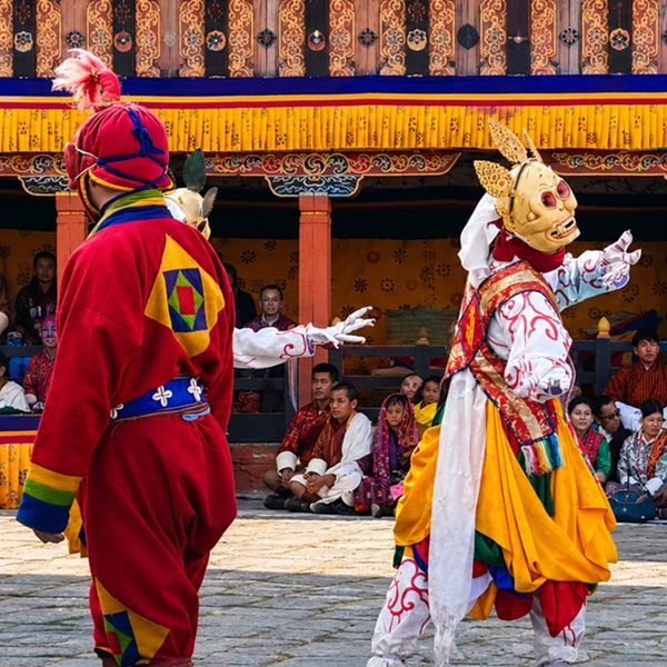
Trashigang Dzong, raised in 1659 on a spur above the water, controlled the old trade route to Tibet and now hosts one of the east's great winter festivals; even empty, its courtyard overlooks the gorge and justifies the journey alone.
The town square is small enough to learn in an evening — a prayer wheel, a fig tree, two rows of shophouses where Brokpa herders in black yak-hair hats come down to trade.
Ara, the local rice-and-maize spirit, is served warm here, sometimes with a fried egg stirred through it. Accept a cup slowly; refills arrive without being asked.
Day trips radiate out. Gomphu Kora, 40 minutes north, is a riverside temple where Guru Rinpoche is held to have subdued a demon; its spring festival draws the whole east to circle the shrine through the night.
Drametse Monastery, back toward Mongar, is the home of the Drametse Ngacham drum dance, inscribed on UNESCO's list of intangible cultural heritage.
Trashiyangtse and the Chorten Kora
Trashiyangtse, 90 minutes north of Trashigang, is worth the extra half day for two things: a stupa and a bowl.
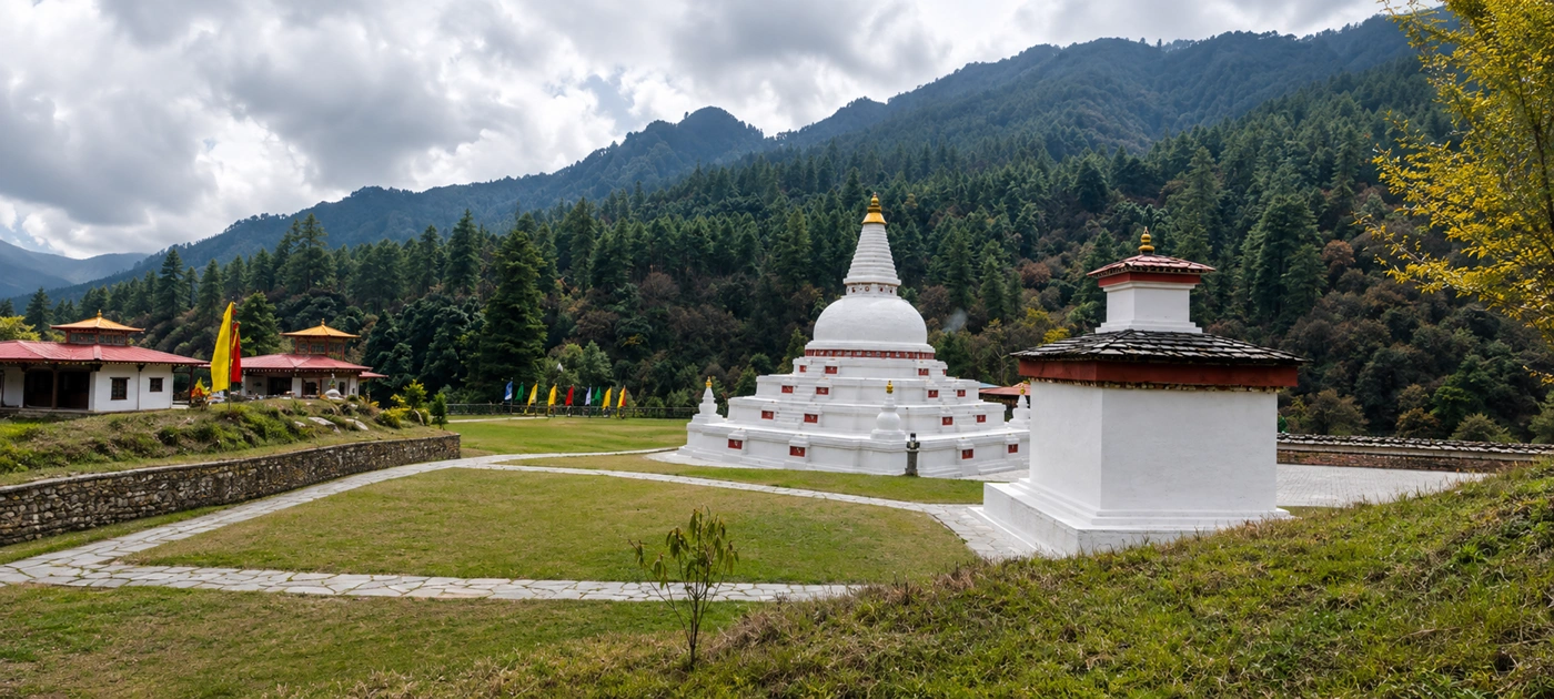
The Chorten Kora is a whitewashed Nepali-style stupa modeled on Boudhanath in Kathmandu — legend holds that the builder carried its likeness home, carved inside a radish, which shrank on the journey, explaining the differences. It anchors a spring festival attended by pilgrims from Arunachal Pradesh across the border.
The bowl is the dapa, the lidded turned-wood dish every Bhutanese household owns. Trashiyangtse is Bhutan's woodturning capital and hosts an eastern branch of the national Zorig Chusum institute, where students train in traditional arts; the workshops sell burlwood dapa, which you'll later see priced triple in Paro.
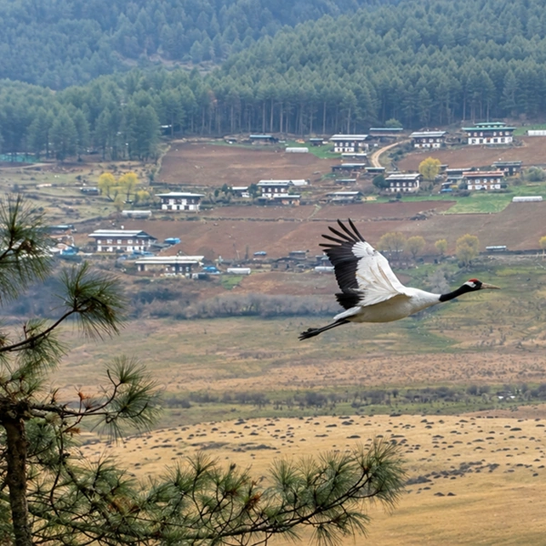
Birders should carry binoculars in winter. The Bomdeling Valley just north is a roosting ground for black-necked cranes — a quieter counterpart to Phobjikha, with none of the crowds.
Merak and Sakteng: the Brokpa Highlands
Merak and Sakteng are the semi-nomadic yak-herding villages of the far east, sitting between roughly 3,000 and 3,500 meters inside the Sakteng Wildlife Sanctuary.
The Brokpa who live there remain culturally distinct from lowland Bhutan — their own dialect, red yak-wool jackets, and the tsipee cham, a black felted hat with spider-leg tails that channel rain off the face.
Reaching them is the East's genuine adventure. Roads now run close to both villages, but the classic approach is a two-to-three-day trek over the Nyakchungla Pass through rhododendron and yak pasture, overnighting in village homestays or supported camps.
The sanctuary is also, famously, the only protected area on earth established partly with the migoi — the yeti — in mind, a detail the rangers relay with a completely straight face.
This extension suits travelers with two to three spare days. We stage it from Trashigang with our own crew walking in ahead of you, and treat it as an add-on rather than a default.
When to visit eastern Bhutan
October to early December and late February to April are the windows we book for the east. Autumn brings washed skies after the monsoon and the clearest long views from the passes; late winter is dry, mild in the low valleys, and timed to the eastern festival season, when Trashigang's dzong festival and the Gomphu Kora and Chorten Kora gatherings fall by the lunar calendar. Exact festival dates shift each year and are confirmed at the time of booking.
Because Trashigang and the Kuri Chhu valley sit so low, the east stays comfortable when western Bhutan is frosty — daytime winter temperatures in Trashigang commonly reach the high teens Celsius.
The trade-off is summer: monsoon rains hit the eastern hills hard, and the Thrumshingla road is prone to blockages from June to September. We don't route guests east in those months.
How we travel the east
Our Eastern Bhutan journey runs privately only: your own guide, your own vehicle, and a route built around the Yongphulla flight so the lateral road is driven once at your pace.
Every day is adjustable — a second morning in Khoma, the Merak extension, or an exit south through Samdrup Jongkhar to Guwahati for onward travel in India are all standing options rather than special requests.
Bhutan's daily Sustainable Development Fee and visa are handled by us and included in your quote; the current figures and process are in our Bhutan SDF and visa guide.
If the west is Bhutan's stage, the east is its workshop — looms, lathes, herds, and dzongs still doing the jobs they were built for. Travel it before the road gets famous.
When you're ready to look at routes and dates, our Eastern Bhutan Luxury Tour is the itinerary this guide walks alongside, and we'll shape it around the valleys that pull you most.
FAQs
How do you reach eastern Bhutan from Paro or Thimphu?
Two ways: drive the lateral road east through Bumthang and over the Thrumshingla Pass, or fly Druk Air's domestic service from Paro to Yongphulla, the airstrip above Trashigang. We usually combine them — drive east over two to three days so the road is part of the trip, then fly back to Paro in under an hour. Domestic schedules are thin and weather-dependent, so every itinerary carries a road fallback.
Is the drive over the Thrumshingla Pass difficult?
It's long rather than dangerous. The road is paved but narrow, crossing the pass at about 3,750 meters before descending nearly 3,000 vertical meters to the Kuri Chhu — a five-to-seven-hour stage from Bumthang to Mongar with stops. Travelers prone to motion sickness should sit in the front seat and take medication beforehand; our drivers break the descent at Sengor or Lingmethang rather than driving straight through.
What is Khoma village in Lhuentse famous for?
Khoma is Bhutan's center of kishuthara, the patterned silk brocade considered the country's finest weaving. Most households in the village weave on backstrap looms, and an intricate full kira can occupy a weaver for close to a year. The village is a 45-minute walk from the road below Lhuentse Dzong, and buying directly from a weaver's porch is both cheaper and offers better provenance than any Thimphu shop.
How many days does an Eastern Bhutan itinerary need?
Plan four to six days east of Bumthang for the core circuit — Mongar, Lhuentse and Khoma, Trashigang with Gomphu Kora, and Trashiyangtse — plus two to three more if you add the Merak–Sakteng trek. With flights and the western valleys included, a full Bhutan journey featuring the east runs comfortably at ten to twelve days. Shorter than that, and the east becomes a drive-through, which defeats its purpose.
Do Merak and Sakteng require anything beyond the standard Bhutan visa?
Your Bhutan visa covers travel to Merak and Sakteng, but the area lies within the Sakteng Wildlife Sanctuary, and visits are conducted as guided treks or homestay stays arranged through a licensed operator. We handle the sanctuary formalities, crew, and homestay bookings as part of the itinerary. Expect nights at 3,000 meters or higher, so the extension should come after acclimatization days, not at the start of the trip.
Is Trashigang warmer than western Bhutan?
Noticeably. Trashigang town sits near 1,150 meters — far lower than Paro at 2,200 or Bumthang above 2,600 — so winter days there are mild while the western valleys frost overnight. That low, warm belt along the Drangme Chhu is why the east grows maize, oranges, and lemongrass rather than the buckwheat of the high valleys, and it makes late winter one of the best times for an eastern circuit.
Can you exit Bhutan through Samdrup Jongkhar after touring the east?
Yes — the southeastern road border at Samdrup Jongkhar connects to Assam, with Guwahati airport about three hours beyond, and it's a natural one-way exit after an eastern circuit instead of backtracking west. We arrange the exit formalities and an Indian transfer when the routing suits your onward plans. Border operating status can change, so we confirm it during trip planning at the time of booking.
Why do so few travelers see eastern Bhutan?
Distance and airline seats, mostly. The east is two long driving days or a scarce domestic flight from Paro, so standard week-long itineraries never reach it — the great majority of visitors stay within the Paro–Thimphu–Punakha triangle. The result is the imbalance you travel for: dzongs without queues, festivals attended almost entirely by locals, and villages where a visitor is still a conversation, not a transaction.