The Druk Path trek is Bhutan's classic short trek, a ridgeline walk of roughly 50 kilometers connecting Paro and Thimphu in four to five walking days. It never drops into a road, a village, or a shop.
Instead, it follows the crest that separates the two valleys, stringing together a small hilltop dzong, yak herder pastures, and a chain of dark alpine lakes that sit just above 3,800 meters.
That combination is why we recommend it so often. It fits inside a ten-day Bhutan journey — the trek-plus-culture format that most of our luxury travel itineraries in the Himalayas follow — reaches genuine high country without extreme altitude, and ends almost literally at the door of the capital.
You walk out of one valley and, five days later, descend past a working monastery into the other.
What Is the Druk Path Trek?
The Druk Path trek is a point-to-point camping route from the Paro Valley to Thimphu, crossing the ridge that divides them and topping out at a pass of about 4,210 meters. "Druk Path" means the path of the Thunder Dragon — Druk is Bhutan's own name for itself, Druk Yul, land of the dragon. Herders and monks used this crest trail long before trekkers did; Phajoding Monastery at the Thimphu end has drawn foot traffic over these hills since the 13th century.
There is no motorable road anywhere on the route. Everything moves the way it always has, on hooves and shoulders, which is precisely what keeps the trail quiet. On our departures outside the peak weeks, it's common to share a whole afternoon with nobody but a yak herder and his dogs.
The trek is short by Himalayan standards, but it is not a stroll. Four of the five days are above 3,500 meters, and the nights are cold in every season. It rewards walkers who arrive acclimatized and travel with a camp that works properly at altitude — more on both below.
The Route: Dzong, Pastures, and Lakes
The Druk Path runs south-to-north along the crest in five stages: up from Paro to Jele Dzong, along yak pastures to Jangchulakha, past the lakes at Jimilang Tsho and Simkotra Tsho, over the high pass, and down through Phajoding into Thimphu.
Each stage has its own character, so it never feels like the same day repeated.
Jele Dzong: The First Night's Fortress
The walk begins above Paro's National Museum, climbing steadily through blue pine and, higher up, through gnarled oak draped in old-man's-beard lichen.
It's the biggest ascent of the trek — around 1,000 meters of height gain — and it ends at Jele Dzong, a small whitewashed fortress-monastery standing alone on the ridge at roughly 3,570 meters.
On a clear evening, the Paro Valley unrolls below the camp, with Jomolhari, at 7,326 meters, rising on the northern horizon.
Jangchulakha: Yak Country
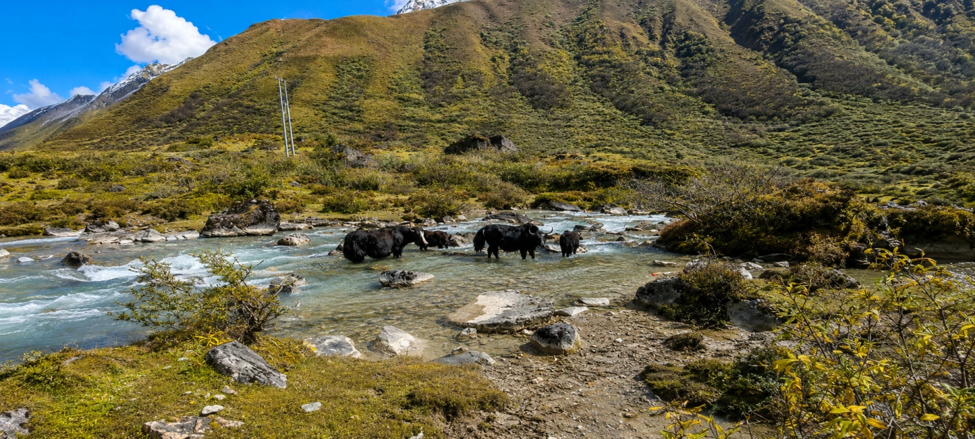
The second stage stays high, weaving through dwarf rhododendron and juniper along the crest to the herding grounds at Jangchulakha, near 3,780 meters.
This is working pasture, not scenery. Black yak-hair herder tents appear through the mist, bells clank somewhere below the trail, and our crew gives grazing yaks the wide berth they deserve.
Jimilang Tsho: The Lake of the Giant Trout
Jimilang Tsho is the largest lake on the Druk Path trek, sitting in a rocky bowl at about 3,870 meters and known across Bhutan for its unusually large golden trout.
The name translates roughly as "Sand Ox Lake," after a legendary bull said to have risen from its waters. Camp sits close to the shore, and the light in the last hour before dusk — grey stone, black water, prayer flags — is one of the finest photography stops in western Bhutan.
Bhutanese tradition treats high lakes as the homes of protector deities. Our guides brief guests the evening before: voices low near the water, nothing washed in the lake, nothing thrown in, no swimming. It's a small courtesy that matters a great deal here.
Simkotra Tsho and the High Pass
From Jimilang Tsho, the trail passes the smaller Janetsho Lake before climbing to Simkotra Tsho at around 4,110 meters, the highest camp of the trek, beside the ruins of an old dzong.
The following morning crosses the trek's high point — the pass above Labana at about 4,210 meters.
This is the day the big mountains show themselves: in clear weather, the northern skyline runs from Jomolhari across to Gangkar Puensum, at 7,570 meters, the highest unclimbed mountain on earth, protected by Bhutanese law from any ascent.
Phajoding: Descending Into Thimphu
The final stage drops past the meditation retreats and temples of Phajoding Monastery, scattered across the slope at about 3,650 meters, where young monks still study a morning's steep walk above the capital.
Below the monastery, the trail enters a long forest descent to Motithang, on Thimphu's upper edge.
There's a particular bend about twenty minutes below the main temple where the trees open and the whole capital appears at once — after five days of ridgeline and lakes, the sight of traffic and rooftops is genuinely strange.
Our vehicle waits at the trailhead, and you're at a hot shower within the half hour.
How Hard Is the Druk Path Trek?
The Druk Path trek is a moderate trek: short daily distances of 8 to 12 kilometers, but sustained altitude, with four nights above 3,500 meters and a pass at about 4,210 meters.
Nobody needs mountaineering experience. What the route asks for is steady legs on the rocky ridge trail, tolerance for cold nights, and sensible acclimatization before you start.
The first day's 1,000-meter climb to Jele Dzong is the physical crux.
The altitude crux comes later, at the Simkotra camp near 4,110 meters, which is why we structure the days so that sleeping height rises gradually rather than front-loading the gain.
Our standard practice is to schedule the Tiger's Nest hike in Paro the day before the trek begins, not after.
That morning to 3,120 meters, plus two nights sleeping in the Paro Valley at 2,200 meters, does more for how you feel at Jimilang Tsho than any supplement will.
A private guide also means the pace is genuinely yours — we've run this route in six easy stages for guests who wanted shorter days, because a private departure can simply do that.
Best Time for the Druk Path Trek
The best seasons for the Druk Path trek are spring (March to May) and autumn (late September to November). Each window offers something different, and the choice shapes the trek more than most people expect.
Spring turns the middle stages into a rhododendron corridor — whole hillsides of pink and crimson bloom between Jele Dzong and Jangchulakha, at their peak in April.
The trade-off is haze: warm-season air can soften the distant peaks. Autumn reverses the deal.
The flowers are gone, but post-monsoon skies are at their clearest, and the pass-day panorama toward Gangkar Puensum is most reliable from mid-October onward.
Winter treks are possible in December on settled days, with hard frosts and occasional snow on the pass; we only run them with a flexible itinerary.
The monsoon months of June to early September we skip entirely — the ridge lives in cloud, and the leeches in the lower forest are nobody's idea of luxury.
Camping on the Druk Path, Bhutan-Style
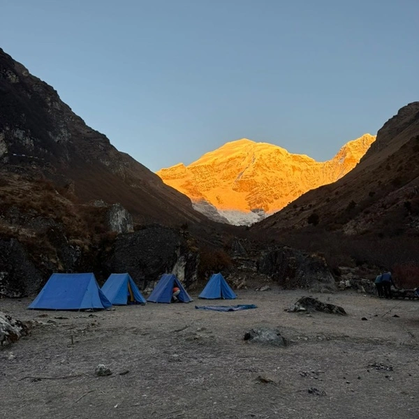
There are no lodges anywhere on the Druk Path trek — every night is spent under canvas, which is exactly where the gap between a standard trek and ours shows most. Bhutanese treks are horse-supported: pack animals carry the camp, and the crew moves ahead of the walking group.
On our departures, that crew belongs to you alone.
They break camp after breakfast, overtake you on the trail, and have the next camp standing before you arrive — sleeping tents with proper mattresses and pillows, a dining tent with table and chairs, a toilet tent, and hot washing water waiting.
Dinner comes in courses from a kitchen tent: soup, a Bhutanese dish such as kewa datshi, potatoes in chili and cheese, alongside milder plates, and dessert.
At bedtime, there's a hot water bottle in your sleeping bag. At 3,870 meters, that last detail is the one guests mention for years.
Mornings start with "bed tea" brought to the tent flap before the sun clears the ridge. It's a small ritual, but it turns a cold camp dawn into something you'll miss when the trek ends.
Permits, the SDF, and How the Trek Is Arranged
All Druk Path trekkers travel on a Bhutanese visa arranged through a licensed operator, pay the government's Sustainable Development Fee for each night in the country, and walk with a licensed Bhutanese guide — independent trekking isn't available in Bhutan.
The trekking route itself also requires registration, which the operator files.
None of this needs to touch you. We arrange the visa, the SDF, the route registration, and the camp crew as a single package, and confirm all current government fees in writing in your proposal, since the figures are set by the Royal Government and can change.
Our guide to Bhutan's SDF and visa process explains how the system works and what the fee actually funds—healthcare, education, and the forest cover that keeps this ridge green.
Flights matter more than paperwork here. Paro's airport sits deep in the valley, and seats for the high season sell out months in advance. We hold flight arrangements as early as the trek dates themselves.
Walking It Privately
A private Druk Path departure changes three things: the pace is yours, the camp is yours, and the route can flex.
We can add a sixth stage for easier days, hold an extra night at Jimilang Tsho for photographers, or reverse the direction to finish in Paro when your onward flight suits it.
The ridge doesn't care which way you walk it; the light at the lakes is good in both directions.
If the trek is calling, our five-day Bhutan Druk Path trek offers a fully private itinerary, and we shape it around your dates. The Himalaya, Privately Yours.
Druk Path Trek FAQs
How high is the highest point on the Druk Path trek?
The Druk Path trek tops out at a pass of about 4,210 meters, crossed on the morning after the Simkotra Tsho camp. The highest sleeping altitude is Simkotra itself at around 4,110 meters. These are honest high-country numbers, but the gradual profile — each camp only a few hundred meters above the last — keeps the altitude manageable for well-acclimatized walkers. Exact figures vary slightly between survey sources, which is normal for Bhutanese trail data.
Are there lodges on the Druk Path trek, or is it camping only?
Camping only — no lodges, teahouses, or homestays exist anywhere on the ridge between Paro and Thimphu. Every operator runs the route as a horse-supported camping trek. The quality of that camp is therefore the single biggest difference between departures: crew ratio, tent standard, food, and whether the camp is shared or private. Ours is private, staffed for you alone, with a dining tent and hot water bottles at night.
Which lake on the Druk Path holds the famous giant trout?
Jimilang Tsho, the largest lake on the route at about 3,870 meters, is the one known for its unusually large golden trout. Bhutanese tradition holds high lakes sacred as homes of protector deities, so the fish are left entirely alone — no fishing, no swimming, nothing washed or thrown in the water. Our guides brief guests on lake etiquette the evening before arrival, and camp is set a respectful distance from the shore.
Can beginners do the Druk Path trek in Bhutan?
Yes, provided they're comfortable walking five to six hours a day on a rocky trail and arrive with two acclimatization nights in Paro first. The Druk Path is graded moderate: daily distances are short at 8 to 12 kilometers, and the biggest climb is the first day's 1,000 meters to Jele Dzong. On private departures, we can also stretch the route to six stages, which shortens every day and makes it a genuinely gentle introduction to Himalayan trekking.
When does snow close the pass on the Druk Path trek?
Snow can lie on the pass above Labana from late December through February, and heavy snow years can make the crossing impractical without full winter equipment. December departures in settled weather are workable and beautifully quiet; for January and February, we generally advise against them. By mid-March, the trail reopens reliably, and from then until May, the snow question gives way to the rhododendron one.
Can you see Gangkar Puensum from the Druk Path trek?
Yes — on a clear day, the pass crossing above Simkotra Tsho gives a long northern panorama that includes Gangkar Puensum at 7,570 meters, the highest unclimbed mountain in the world. Bhutan prohibits mountaineering on its high peaks out of respect for the deities believed to dwell there, so the summit has never been reached. Clarity is most reliable from mid-October to early December, after the monsoon has washed the sky.
Does the Druk Path trek end in Thimphu itself?
Effectively, yes. The final descent passes Phajoding Monastery and reaches the road at Motithang, on the upper western edge of Thimphu — the drive from trailhead to the city's hotels takes well under thirty minutes. It's one of the very few Himalayan treks that finishes at a capital city, which is why we usually place Thimphu's dzongs, weekend market, and restaurants immediately after the trek as a soft landing.